Tuesday 2nd August
When we were in Katherine a helpful lady in the tourist information centre recommended the Guluyambi Cultural Cruise. She gave us a brochure on the cruise and said she could help us with bookings – or we could go online and do it ourselves. We said we would go away and check out the brochure in more detail. It was only when we got back to our Nitmiluk campsite that we flipped over the brochure and saw the same company was providing full day tours into Arnhem Land – to visit a number of rock art sites, as well as areas of cultural significance while also taking in some of the unique scenery that defines this part of the country.
We have long spoken about visiting the Cobourg Peninsula in Arnhem Land, but a number of factors have made that difficult (Covid to name a recent one). We saw this tour as a small way of getting introduced to what is on the other side of Cahill’s Crossing.
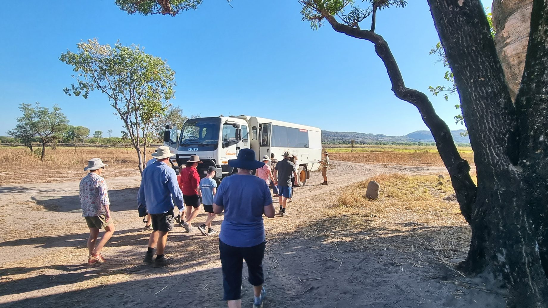
The tour bus started picking up passengers in Jabiru early in the morning, before stopping at the Border Store to pick us up at around 8.30am. It was only a very short drive from there to Cahill’s Crossing (named after a pioneer pastoralist and buffalo hunter, who developed what was a natural rock crossing into something more substantial over the years). Further work has been done on the tidal causeway to stop vehicles being washed off the side when the tide is running. Nick, our tour guide and 4WD bus / truck driver, said we would stop and take a closer look on our return trip when the run-in tide would be inspiring plenty of crocodile activity.
Once into Arnhem Land we were immediately confronted with three large buffalo running across the graded gravel road and off into the wetland to our left. Buffalo were introduced to this area from Indonesia in the late 1800s and have subsequently become one of the feral animals (along with wild pigs) that cause considerable damage to the wetlands environment. The bus stopped to allow us to watch the beasts gallop away some 50 metres before turning to make sure they were a safe distance away from us. Buffalo are hunted through Arnhem Land for food, as well as to keep the numbers down and their impact to a minimum. As a result they have grown very cautious around people.
We weren’t back on our way for long before a large, flat-topped tree was pointed out. It contained a pair of nesting jabirus and two fledglings who were getting close to flying off and looking after themselves. The favourite food the jabirus gather for their chicks are baby crocodiles, which are apparently in abundance in the area. Our next attempt at driving further into Arnhem Land was interrupted by three brolga feeding in the wetlands about 30 metres to our left.
Our journey continued along the main Arnhem Highway for a short while before we took a side track into an area that had previously been used for men’s initiation ceremonies. Its use had ceased when the Arnhem Highway had been pushed through and the sacred site was deemed too close to the busy road. An alternative was sought.
Part of the initiation ceremony was to demonstrate prowess with a spear and to do so, those being initiated had to throw a spear at a target high up on the nearby cliff face from a designated area on the ground. Proof that this was the case were seven spear heads wedged in a crack in the rock face high above our vantage point.

Apparently our collective prowess at getting on and off the tour bus, without the aid of an additional ‘baby’ step, inspired our guide to suggest a change to the itinerary for the day; he would take us to a rock art gallery high up on one of the escarpments overlooking the wetlands below. The climb / scramble had all 13 members of the tour group puffing by the time we made it to the first of many galleries scattered through the rock overhangs. There were some galleries where taking photos was allowed and others where we needed to show respect and put the cameras away. The vista out over the wetlands below was also worth the climb.

The art on display depicted many things, from the food available in the area to very ancient figures following a line of sacred rocks that we had seen on our ascent of the escarpment. We learnt that dating rock art is not a precise science. Estimates on the age of some of the oldest art we were shown suggested it was upwards of 23,000 years. Some of the art featured during the day included animals that were long gone from the region, including the big red kangaroos that now live in central Australia. More modern art depicted Darwin luggers that supplied communities along the coast, offshore islands, and up the major rivers out of Darwin. We also saw work that is attributed to the Mimi spirits that live in the cracks of the rocks and can complete rock art paintings in places others would struggle to reach.


Lunch was taken beside Inkiyu Billabong, about 20 minutes drive along a rough track that would be inundated with water in the wet season. The billabong itself would also be flooded and join up with the East Alligator River, which would allow the passage of fish and crocodiles from one environment to the other. As a result, we were warned to keep at least 15 metres back from the water’s edge at all times. There was also a strong smell of buffalo in the air when we stopped, and we were further warned to make for the bus should a territorial bull approach.

Inkiyu Billabong was a shady and peaceful setting for lunch, with travel tales shared over a chicken salad, chocolate cake, and a refreshing lemongrass iced tea. After eating we walked to an area a little away from the lunch spot to take in the grander of the views deeper into the surrounding gorges, before returning to the bus and starting our return journey.
The return crossing of the causeway over the East Alligator River was always going to be interesting, as the run-in tide was going to be in full flow. When this happens the fish in the river attempt to move upstream, while an impressive number of crocodiles position themselves around the causeway for an easy meal. Today was no exception.
The bus stopped on the Arnhem Land side of the causeway and we all cautiously approached the action below, always maintaining a safe distance between ourselves and the water. At one stage we could count 15 crocodiles upstream and 13 downstream – and they were only the ones we could see! The water is opaque, and impossible to see anything below the surface as it is full of silt. Fish would jump and jaws would snap. Crocs would disappear into the murky waters without a ripple as others appeared as if from nowhere. It’s only a matter of time before over-zealous visitors get too close and actually become part of the action. The new observation area being constructed can’t come soon enough.


We returned to the bus and got an upfront view of the lurking crocodiles as we rumbled across the knee-deep water flowing upstream over the causeway. When we first came here many years ago, a tour guide we spoke to said it was the first place he took visitors to as it made very clear there are crocodiles in Kakadu and they need to be respected. Our tour ended back at the Border Store where we said our farewells to our fellow travellers and thanked our guide, Nick, for an informative, interesting and enjoyable day to remember.
Following another icy pole and a cool drink, we drove the short distance to the downstream launching ramp where there is a picnic table set high above the river. We spent ages here on our first visit “croc spotting”, and found today that it is just as easy to spot them now as it was back then. Some fairly uneducated (when it comes to crocodiles) young women arrived and were quite shocked / surprised at the number of crocs they could see, the size of many of them, and how close they would approach to the riverbank. They retreated to the safety of the picnic table area for a more discreet view of proceedings.


Our day wasn’t over yet, as Chris had been wanting to check out the sunset from atop the Ubirr escarpment since we arrived at this end of Kakadu. After a short rest back at camp we set off for Ubirr at 5.45pm, arriving to a full carpark about 10 minutes later. We followed the stream of visitors along the path leading to the top of the escarpment, and could already make out the silhouettes of dozens and dozens of people all gazing to the west. We made our way to the top, amazed at the number of people gathered there, and looked westward into a dense cloud of billowing smoke on the horizon (from one of the many cool burns that are currently underway within Kakadu). Chris speculated that the smoke was so thick it would blot out the sun as it passed behind. As the sun disappeared behind the cloud of smoke, the temperature dropped sufficiently for there to be a rush of warm smoky air from the west, blanketing everything in a smoky fog that smelt of bushfire.

The hoped for a stunning sunset never eventuated, and we returned to camp through a cloud of smoke. Any thoughts of the smoke deterring the mosquitoes tonight were dashed when we got out of the Prado only to have a persistent cloud of them descend upon us. There were so many insects buzzing around we chose to eat dinner inside the Tvan. (This was possibly only the second time we have dined inside, the other being a dust storm at William Creek on the Oodnadatta Track in South Australia many years ago).
Tomorrow we pack up and head west to a campground beside the Mary River. Fingers crossed we leave some of the insects behind!